ÖTILLÖ Engadin 2026
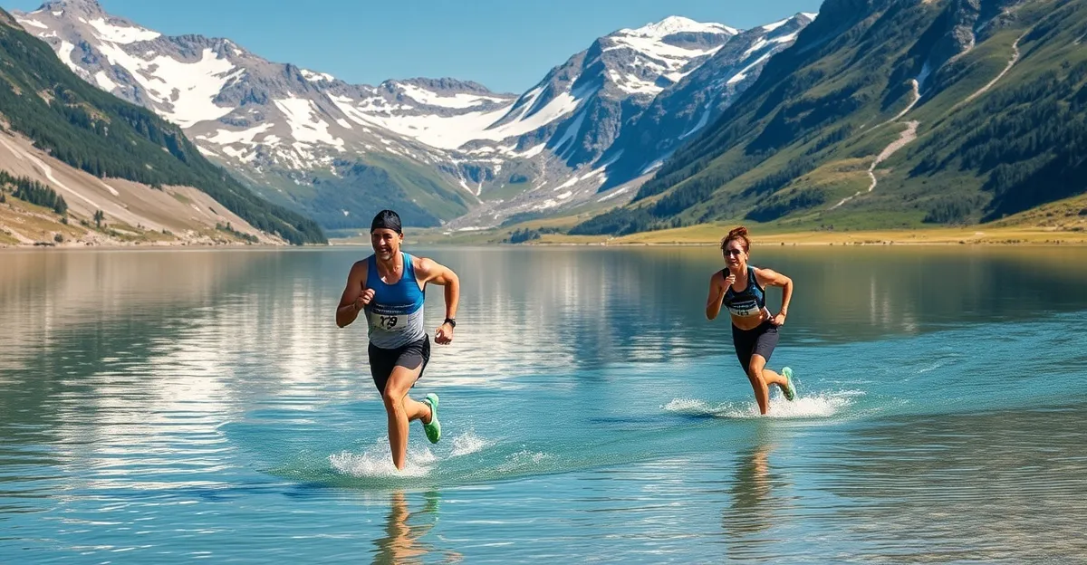
ÖTILLÖ Engadin is widely regarded as the most beautiful course on the entire ÖTILLÖ World Series calendar. Set in the Upper Engadin valley of south-eastern Switzerland, the race takes athletes through a chain of crystal-clear alpine lakes connected by mountain trails, with the snow-capped peaks of the Bernina range as a constant backdrop. It is swimrun at altitude — challenging, breathtaking, and utterly unique.
The Engadin valley sits between 1,700 and 1,900 metres above sea level, making this the highest-altitude ÖTILLÖ race. The thin mountain air adds a physiological dimension that sea-level races lack. Athletes who underestimate the altitude pay for it on the run sections, where oxygen debt accumulates faster than expected.
Course and Venue
The ÖTILLÖ Engadin course links the famous chain of Engadin lakes — Silvaplana, Champfèr, St. Moritz, Staz, and others — with mountain trails that traverse meadows, forests, and rocky alpine terrain. The turquoise colour of these glacier-fed lakes is not a marketing photograph; the water genuinely looks like that.
- Sprint: Approximately 7.1km, 2-3 lake swims — a spectacular introduction to alpine swimrun
- Experience: Mid-distance, approximately 20-25km across several lakes
- Full: 43.4km, traversing the full chain of Engadin lakes — the premier distance
- Terrain: Alpine meadow paths, forest single-track, rocky mountain trails, some gravel roads
- Swim sections: Clear, cold alpine lakes ranging from small tarns to substantial crossings of Lake Silvaplana
- Elevation gain: Significant — expect 800-1,200m of climbing on the full course
- Altitude: 1,700-1,900m above sea level throughout
Lake Silvaplana is known for its afternoon thermal winds (the Maloja wind), which can create choppy conditions on the larger crossings. The morning start typically avoids the worst of this, but conditions can change rapidly in the mountains.
Getting to the Engadin
By Air and Train
The most practical route is flying to Zurich Airport (ZRH) and taking the train to the Engadin. Swiss Federal Railways (SBB) connects Zurich to Chur, where you transfer to the Rhaetian Railway (RhB) for the scenic climb to St. Moritz or Samedan. The total journey takes approximately 3.5 hours. The Albula line section is a UNESCO World Heritage route — a memorable approach to the race venue.
Alternatively, fly to Milan Malpensa (MXP) and drive approximately 3 hours north via Chiavenna and the Maloja Pass. Innsbruck (INN) is another option, approximately 3 hours by car via the Julier or Flüela Pass.
By Car
From Zurich, drive approximately 3 hours via the Julier Pass (open year-round) or take the car-train through the Vereina Tunnel from Klosters. From Munich, the drive is approximately 3.5 hours via Austria and the Lower Engadin. Swiss motorway vignettes are required.
Accommodation
The Upper Engadin is a well-established resort region with ample accommodation, though prices reflect the St. Moritz postcode. July is high season — book as early as possible.
- St. Moritz: Full range from luxury to mid-range, closest to the lake venues, best restaurant selection
- Samedan: The neighbouring town, slightly more affordable, excellent train connections, many athletes stay here
- Pontresina: A quieter mountain village 10 minutes from St. Moritz, strong hiking and climbing culture
- Silvaplana: Directly on the lake, popular with windsurfers and kitesurfers, compact but convenient
- Celerina: Between Samedan and St. Moritz, often the best value for the location
Holiday apartments and Airbnb options are available throughout the valley and are often more practical for teams who want to prepare their own meals and manage race nutrition.
Training Tips for the Engadin
The combination of altitude and cold alpine water makes ÖTILLÖ Engadin uniquely demanding. Specific preparation should include:
- Altitude acclimatisation: Arrive 1-2 days early if possible. At 1,800m, you will notice the thinner air during intense efforts. If you live at sea level, add high-intensity interval sessions to your training to prepare for the oxygen debt.
- Cold lake swimming: The alpine lakes are colder than coastal races. A 2-3mm wetsuit is standard, but if you run cold, consider neoprene accessories (cap, gloves).
- Uphill running endurance: With 800-1,200m of climbing on the full course, include substantial hill training. Practice running uphill in your wetsuit — it is harder than it sounds.
- Trail shoe selection: The terrain varies from soft meadow to rocky alpine paths. Choose a shoe with moderate grip and protection — the footing is more varied than at coastal ÖTILLÖ races.
- Sun protection: UV intensity is significantly higher at 1,800m. Waterproof sunscreen is essential, applied before the wetsuit goes on.
Use the Swimrun Pace Calculator to estimate your finish time, and add 10-15% to your expected run splits if you are not acclimatised to altitude.
Nearby ÖTILLÖ Races
- ÖTILLÖ Gothenburg 2026 — July 25, Swedish west coast (3 weeks later)
- ÖTILLÖ Cannes 2026 — October 3, French Riviera (accessible from Switzerland)
- ÖTILLÖ World Championship 2026 — September 7, Stockholm (Engadin is a key qualifier)
Frequently Asked Questions
When is ÖTILLÖ Engadin 2026?
ÖTILLÖ Engadin 2026 takes place on July 4, 2026 in the Upper Engadin valley, Switzerland, near St. Moritz and Samedan.
What distances are available at ÖTILLÖ Engadin?
ÖTILLÖ Engadin offers distances from approximately 7.1km sprint to 43.4km full distance, with multiple intermediate categories. The full course traverses the entire chain of Engadin lakes.
How do you get to the Engadin for the race?
Fly to Zurich Airport (ZRH) and take the train to St. Moritz or Samedan — the scenic Glacier Express or standard SBB/RhB route takes approximately 3.5 hours. Alternatively, fly to Milan Malpensa (MXP) and drive approximately 3 hours via the Maloja Pass.
What is the water temperature in the Engadin lakes in July?
The Engadin lakes sit at approximately 1,800m altitude. Water temperatures in early July typically range from 14-18°C depending on the lake and weather. A 2-3mm wetsuit is recommended.
How does altitude affect the ÖTILLÖ Engadin race?
The Engadin valley sits at 1,700-1,900m above sea level. Athletes not accustomed to altitude should arrive 1-2 days early to acclimatise. Running effort feels harder and breathing rate increases at this elevation.
How much does ÖTILLÖ Engadin cost?
Entry fees for ÖTILLÖ Engadin typically range from CHF 200-450 per team depending on the distance category. Switzerland is an expensive destination — budget accordingly for accommodation, meals, and transport.
Ready to Train Smarter?
Get personalized training zones, race predictions, and performance insights with our free calculators.